 |
|
Here’s looking at you, from 685km away
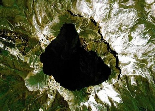
An image of Cheongi Lake at Mount Baekdu, the tallest mountain on the Korean peninsula, which straddles North Korea and China. The photo was taken in a trial run of the Arirang 2 satellite’s imaging capabilities.
|
’Arirang 2’ sends crisp test pictures back from orbit
A multipurpose satellite that South Korea launched into space last month has sent back its first photographs, proving that the images provided by Arirang 2 are vivid enough to distinguish small objects on the ground. The Ministry of Science and Technology and the Korea Aerospace Research Institute (KARI) unveiled the images from the high-resolution cameras of Arirang 2. Photographs include those of Mount Baekdu, the highest peak on the Korean peninsula, the shoreline and airports of South Africa’s Cape Town, and the San Francisco International Airport."The images were obtained earlier than scheduled, and we are satisfied with their quality considering that they were taken as part of a test run," said Paik Hong-yul, head of KARI, in a press briefing just after the release of the photos. "With further adjustment, we will be able to receive even better images," Paik said. Arirang 2 circles the globe 14.5 times a day, 685 kilometers above the earth’s surface. The camera mounted on the satellite has a resolution of one square meter, which means an area of that size can be shown as one pixel.
 |
|
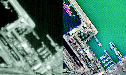
Two photographs of the harbor in Cape Town, South Africa, showing the difference in clarity between images taken by the new Arirang 2 satellite(right) and its predecessor, Arirang 1(left). The older satellite could take photos with a pixel size of 6.6 square meters, whereas Arirang 2’s crisp resolution fits 1 square meter in a pixel. Photo courtesy of Korea Aerospace Research Institute
|